The arch is a single span of basalt blocks, 18 metres long. It was built in the 12th century. People crossed it yesterday.
Built to Connect Two Mountains
The bridge at Sanahin is attributed to Vaneni, wife of the Zakarian prince Ivane I, though some sources hesitate on this attribution. What is certain is that the Zakarians — ambitious Georgian nobles who controlled much of Lori in the 12th and 13th centuries — saw an opportunity. The Debed canyon at this point is a ravine that narrows to a ford in spring, but becomes impassable for most of the year. Haghpat monastery sits on the north wall. Sanahin sits on the south. The two monasteries were connected by years of scholarly exchange and theological debate. They were both centers of Georgian-Armenian cultural life.
A bridge would connect them permanently. Not just physically — the bridge was also symbolic. It said: These two great monasteries are one network. This is managed space. This region is ordered and functioning.
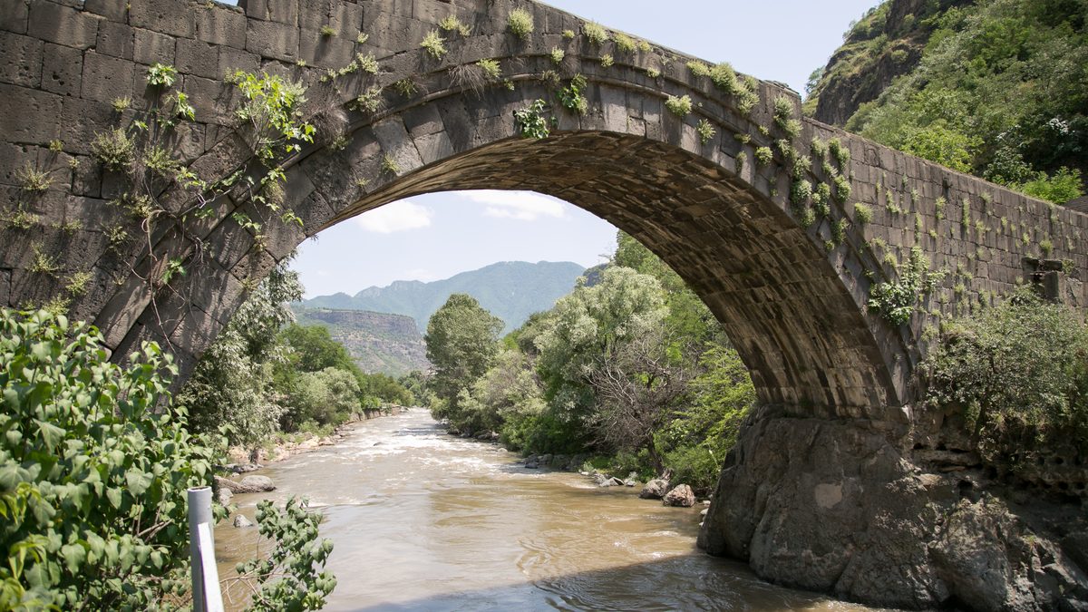
The engineering is elegant. A single pointed arch, characteristic of Armenian medieval bridges. Basalt blocks, cut and fitted. The span is long — 18 meters — which means the arch must be precise. Too shallow and it won't carry weight. Too steep and the forces won't distribute correctly. Whoever designed this understood the mathematics of stone.
What Crossed the Medieval Bridge
For five centuries after the bridge was built, it was a crossing for pilgrims, monks, merchants, and soldiers. The Debed valley was a trade route — goods moving north and south through the Caucasus. A merchant caravan going from Tabriz to Trebizond would take a route that passed through Lori. The bridge made the journey possible.
Monks crossed constantly. There are accounts of theological disputations where Armenian and Georgian scholars traveled between the monasteries to debate interpretation of the scriptures. The bridge was their route. The fact that it existed meant that the two communities were accessible to each other — you could dispute with someone at the other monastery and still be home for evening prayers.
Pilgrims came to see the churches and the monks. The bridge was part of the pilgrimage journey. You walked from the lower Debed valley up to Haghpat, crossed the bridge to Sanahin, saw the churches, and continued on. The bridge was infrastructure that made the sacred landscape accessible.
And soldiers crossed it during the many conflicts that convulsed the region. When power shifted hands, soldiers moved. When an army needed to traverse the canyon, the bridge was a strategic necessity.
The Mongol Invasion and After
In the 13th century, the Mongols invaded. Cities burned. Monasteries were destroyed. Many Armenian churches from this period show evidence of damage or abandonment. The great monastic centers of Armenia were particularly targeted — the Mongols either wanted tribute or wanted to establish control through destruction.
Yet Haghpat and Sanahin survived. The monasteries were not burned. The bridge was not destroyed. Why? The reason most often cited is that the Zakarians, who controlled the region, had made a political accommodation with the Mongol administration. They paid tribute, cooperated with Mongol authority, and in exchange, their properties — including the monasteries — were left largely intact. The bridge survived because the monasteries survived because the Zakarians had read the political moment correctly.
It's a brutal kind of survival, but it's survival. The bridge that was built to celebrate Georgian power in Lori became the bridge that survived because Georgian power was pragmatic enough to negotiate with the Mongols.
The Bridge Through the Centuries
After the medieval period, ownership and control of Lori shifted repeatedly — Ottoman control, Russian control, Soviet control. But the bridge remained in continuous use. It was never "modernized" because there was never enough traffic to justify replacement. The villages on the north and south sides of the canyon continued to exist, but they never grew into towns. The volume of crossing never increased to the point where a modern bridge became necessary.
So the medieval bridge stayed. It became normal. It was just the bridge. Children walked across it going to school — until the 1990s, when the road networks changed and the school routes shifted. Shepherds used it to cross their flocks. Families from one side of the canyon visited family on the other side. It was a monument that was simultaneously infrastructure. It was historic and ordinary.
Today: Still There, Still Standing
Stand on the bridge now. Look down. The stream is 15 meters below, a line of grey water in the canyon. Look at the arch. It's perfect. The curvature is exact. The blocks fit together with minimal gaps. The design has survived 800 years of water erosion, freeze-thaw cycles, occasional floods, and the weight of countless people crossing.
The basalt is covered in lichen — grey and white patterns that look deliberate, decorative. The blocks have smoothed slightly from foot traffic. In some places you can see where the original surface has been worn to a shine. These are the paths people took crossing the bridge, wearing the stone slightly smoother with each crossing.
The bridge is not a museum piece protected behind a fence. It's a bridge that still carries people. It connects two sides of a canyon. It does what it was built to do. And in doing that ordinary work, it has become extraordinary — a medieval engineering achievement that still functions after eight centuries, not as a relic but as infrastructure that works.